### Dead Reckoning
In dead reckoning the navigator finds his posit...
There still isn’t a consensus on whether the term "dead reckoning” ...
For most ships in the 16th century, the only available means of kee...
The log line is a mechanism to measure the speed of a ship. The mos...
*Landlubber* - a person unfamiliar with the sea or sailing
The poop (or stern) is the back or aft-most part of a ship.

Five Centuries of Dead Reckoning
o
E. G. R. Taylor
THE
term 'dead reckoning', so the
Admiralty Navigation Manual
(1938)
says,
is a corruption of the old 'cfecf-uced reckoning' or 'position by
account', and is used to cover all positions that are obtained from 'the
course the ship steers and her speed through the water,, and from no
other
factors.' (The last italics are ours.) Had Master William Borough, Chief
Pilot of the Muscovy Company, and presently to be appointed to Queen
Elizabeth's Navy Board, come across this definition, he would have
picked a two-fold quarrel with their present Lordships at Whitehall. For
his use and explanation of the term is the earliest of which we have
knowledge, although it does not appear even then to have been new.
'And in keeping your dead reckoning', he wrote in 1^80 (having cer-
tainly never heard any nonsense about ded-uced reckoning) 'it is very
necessary that you do note at the end of every four glasses' (i.e. every
half-watch) 'what way the ship has made, by your best proofs to be used,
and how her way hath been through the water considering the sagge of
the sea to leewards, according as you shall find it growen: and also to
note . . . the wind, upon what point you find it then, and of what force
and strength it be, and what sailes you bear'. Borough was addressing
two experienced ship-masters, and for the old-time pilot there was cer-
tainly no quite separate 'estimated position' to be arrived at (according
to the Manual) when the D.R. position is adjusted for the estimated
effects of winds, currents and tidal streams. And the reason for this was
a very good one, namely that the speed of the ship through the water was
itself still a matter of estimate and not of measurement. The log line had
indeed very recently been invented but, as we shall presently see, it was
known only to a few, and even when known was (like all novelties)
viewed by sailors with suspicion. Most English seamen, and all foreign
pilots,
still determined the ship's way by 'pondering withall what space
she was able to make with such a winde and such direction' as a young
English Jesuit named Stevens put it, when trying to explain to his father
how the Portuguese ship in which he was travelling to Goa in 1579 was
navigated. Landlubbers aboard ship are, of course, a useful source of
information about sea-practice, because they describe all those things
that sailors themselves take for granted, although very likely they mis-
interpret what they see.
Such an observer was the German monk, Felix Faber, who in 1483
went on a pilgrimage to the Holy Land, as a passenger in a three-masted
Mediterranean galley. The pilot was a man skilled in the paths of the sea,
he says, but he had with him other experienced men, astrologers and
augurs (or so Felix imagined them to be) who considered the signs of the
280

FIVE CENTURIES OF DEAD RECKONING 281
stars and the sky, formed a judgment as to the winds, and so directed the
pilot. All alike were expert in the art of judging from the look of the sky
whether it would be stormy or fair weather, taking into account also the
colour of the sea, the behaviour and movements of dolphins and flying
fish, the way that smoke rose, the lights that played on the masthead at
night, and the scintillations from the oars as they were dipped into the
water. At night, too, they could tell the hour simply by inspection of
the stars. They kept a mariner's compass set always against the mast,
besides another on the poop by which a lantern burned at night; and when
at sea they never took their eyes off the latter; there was always someone
watching it, and from time to time he sang out sweetly and melodiously,
an indication that the voyage was going prosperously, while by this
self-
same song the man at the helm was directed how to steer. Nor did the
helmsman ever move the rudder unless by his order who, up above, was
watching the compass; for it was he who discerned whether the ship
was proceeding in a straight line, on a curve or sideways. This last is not
a very seaman-like way of stating what went on, but we understand what
Brother Felix meant. And he continues with the information that besides
the 'Stella Maris' as they called the mariner's needle, naming it from
the star toward which it turned, they had other aids or instruments by
which to judge the courses of the stars and the blowing of the wind,
whereby they picked out those narrow paths of the sea
(semitae
mari-
timae) which must be followed. These aids, no doubt, were a useful
supplement to the astrologers and soothsayers (if such they were, and
not just the master's mate and the bo's'un), for they included a chart
carrying a scale and criss-crossed with
'
thousands and thousands' of lines
(as it seemed to the landsman)—in fact a Mediterranean plain chart or
portulan, on which were painted sixteen or more wind-roses, with the
rhumb lines ruled out in different colours. Every day (says the Brother)
the pilot and his assistants hung over this chart, conferring together, for
from it they could tell where they were, even when no land was
visible, and clouds hid the stars, and from it, too, they learned what course
to follow, from point to point along the 'lines'. Such in short was
navigation by dead reckoning in 1483 as observed by a tyro awed and
mystified, as all plain men then were, by the pilot's boast that he could
set course for an unseen destination, and avoid hidden dangers 'without
sight of sun, moon, or stars', helped only by a compass no broader than
the palm of his hand and a piece of painted parchment.
But to set a course was not to follow that course. The galley could not
sail close to the wind, but must tack to and fro, or 'traverse' as it was
then called, so that it was necessary to keep a traverse board or traverse
book in the steerage, and the course made good had to be worked out
from this each day and entered in the Journal. This meant that something
in the nature of
a
traverse table was required, and in fact a far-off ancestor
of Inman's tables, going back more than five hundred years, has survived
in the sailing directions which form part of Andrea Bianco's Atlas of

282 FIVE CENTURIES OF DEAD RECKONING
1436.*
And the mention of a similar table in a Genoese inventory of
1390 carries the date back farther still. Nor need such a table have even
then been a novelty, for the properties of the right-angled triangle, and
in particular the fact that the ratios which we term the sine, cosine and
tangent of any angle were constant no matter what the dimensions of the
triangle, had been familiar since the propositions of Euclid were once
more studied in the twelfth century. Bianco's table or
Toleta de
Marteloeo,
as it was termed, is a graphically determined set of
values
for the northing
(southing) and easting (westing) corresponding to a run of fixed length
(100 miles) along each of the eight quarters, points, or rhumbs of the
wind, from n\°, 22^°, 33J
0
, &c, up to 90
0
, which makes up a quadrant
of the compass. As the charts of those days were ruled in rhumbs and
showed no latitudes (which were not then observed in navigation) the
term 'd. lat.' does not appear, the columns being headed
alargar,
avancar.
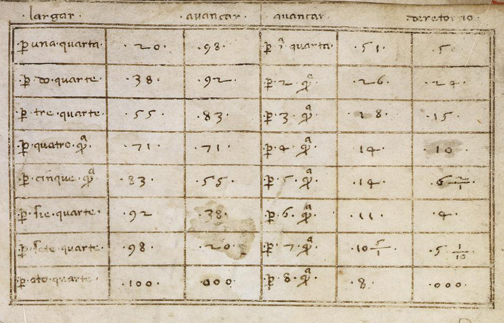
According to the Toleta a ship sailing 100 miles along the sixth point
from North (67J
0
), for example, would make 92 miles easting and 38
miles northing, and so for other distances in proportion, which could be
worked out by proportion, using the Rule of Three or Golden Rule.
Even simple arithmetic was however a stumbling block to the majority,
and Bianco's Atlas also contains a scheme or diagram, constructed on
the principle of the sinical quadrant, from which a graphical solution of
the traverse could be obtained. The basis of the diagram was a large
square accurately subdivided into eight rows of eight small squares. From
the top left-hand corner were drawn the sixteen half-points and points
(beginning at
£%°)
in a quadrant. The whole was surrounded by a circle
showing the principal points of the compass. To indicate how the
diagram was to be used, a naked cherub runs along the top of the large
square, stepping off distances with a pair of dividers nearly as tall as
himself,
and opened to the width of a small square. Presumably the
diagram was intended to be drawn to the same scale as the chart and any
distance pricked off on the one could then be transferred to the other.
The northing and easting were, of course, measured directly from the
'scheme' and no arithmetic was required. With the Great Age of
Discovery, initiated by the Portuguese, long ocean voyages were begun
which required observations of latitude to check the D.R. position, and
latitudes began to be marked in the margin of the portulan chart.
Corresponding tables were eventually prepared by the Jewish mathe-
maticians responsible for working out new navigational methods, among
them the
Table
of
Leagues,
which set out the distances to be sailed along
each rhumb in order to raise or depress the pole one degree, together
with the corresponding easting or westing (departure). The degree of
the meridian was taken as 17^ leagues of 4 miles, and as an example we
can extract the following figures from the table as set out in the oldest
surviving Portuguese navigating manual: 'Item per 6 quartas releva per
grao 46 legoas e mea, at afastaras da lynha direyta 42 legoas per grao et
* It is reproduced in Fontoura da Costa's A
Marinhaiia
do
Descobrimentos
(1933).

FIVE CENTURIES OF DEAD RECKONING 283
mea.' That is to say that sailing along the 6th rhumb the distance required
to raise a degree is 46^ leagues, and the corresponding easting 42^ leagues.
The later Spanish Manuals substituted 16 and two-thirds leagues as the
measure of a degree, and the still later English manuals 60 miles, the
value used by cartographers.
As this brief review shows, seamen of four or five centuries ago would
find no difficulty in working out the daily course made good and the
position reached, provided they could make a correct estimate of the
distance sailed along each leg of the traverse. But this involved knowing
the speed of the ship, and right down to the mid-eighteenth century it was
still usual to rely on the master's or the pilot's judgment. He knew
his ship, and what she could do carrying such and such sail, under a
fresh or a light breeze, with the wind on the poop or on the quarter, and
so on. He had a rule of thumb for estimating leeway, and would help
himself at most by noting the movement of foam alongside, or by throw-
ing a chip overboard and timing its passage between two bolt-heads on
the ship's side. As to the log line, Richard Norwood, when discussing it
in his
Seaman's Practice
in 1637 declared that many sailors were either so
cocksure of their judgment that they disdained to use it, or were shamed
out of doing so because they feared to proclaim themselves 'young
seamen', that is to say inexperienced pilots.
Who invented the log line we do not know, except that he was
certainly an Englishman. The device makes its first appearance very
unobtrusively in William Bourne's
Regiment
of the Sea written about
1
£73.
The author himself was a gunner and therefore not a directly
interested party, but living at Gravesend and being interested in
'
inven-
tions and devices' of a mechanical sort he noticed what was going on.
It is he who tells us that Humfrey Cole, the famous contemporary
instrument maker, had invented a gadget to record the ship's way. But
this was not a log, it was a sort of 'way-wiser' which actually clocked up
the mileage when trailed in the water behind the ship. As for the true
log, 'to know the ship's way', Bourne says, 'some doo use this, which
as I take it is very good. They have a piece of wood, and a line to veere
out overboorde, with a small line of a great lengthe which they make
fast at one ende, and at the other end and middle they have a piece of
lyne which they make fast with a small thred to stand lyke unto a crow-
foote, for this purpose that it should drive asterne as fast as the shippe
doth go away from it, always having the line so ready that it goeth out
as fast as the ship goeth. In the like manner they have either a minute of
an hour glasse, or else a knowne part of an houre by some number of
woordes, or such other lyke, so that the lyne being veered out and
stopped just with that tyme that the glasse is out, or the number of words
spoken which done they hale in the logge or piece of wood again, and
looke how many fathoms the ship hath gone in that time.' So far there
was no question of knotting the line, and the speed had to be worked out
arithmetically, but it appears that the publicity that Bourne gave to the

284
F1VE
CENTURIES OF DEAD RECKONING
log caused more sailors to try it; and not always satisfactorily, for in a
later edition of the Regiment he adds some practical hints, in particular
that the mark on the line at which counting begins should be two or
three fathoms from the billet (later it was much more than this), so that
the log floated well clear of the dead water or eddies at the stern. He
observes that the use of
a
form of words is preferable to the minute glass,
and should be repeated two or three times if the ship is moving slowly.
No doubt the first minute (and later half-minute) glasses were not
accurately made, for such small divisions of time had hitherto hardly
been considered. Several materials besides fine sand began to be used,
including ground-up shells and particles of metal, which were thought
to run more smoothly; and Emery Molyneux, the compass and globe
maker, gained a reputation for making reliable glasses.
m l
S99, the i £87 edition of Bourne's book was translated into Dutch
and so our neighbours learned to use the log, but Fournier in his great
work on hydrography (which included navigation) published in 1643
still speaks of it as a specifically English instrument. By his day the line
had been knotted in such a way as to eliminate arithmetical calculation
and this improvement probably took place by the turn of the century,
for when Edmund Gunter, the mathematician, and Richard Norwood,
a prominent teacher of navigation, came to discuss the matter twenty or
thirty years later the stereotyped, practice was to knot the line every
7 fathoms and run it out for 30 seconds. In this way every knot run
represented approximately a mile an hour and the unit of speed became
known as the knot. The two writers mentioned were concerned, how-
ever, with the interpretation of the ship's run in terms of latitude and
longitude. It was commonly accepted that 5000 feet made a mile (7
fathoms in 30 seconds gave £040 ft. an hour), and 60 miles or 300,000 ft.
made a degree. But by the seventeenth century it was becoming more and
more apparent that the true degree was much more than 300,000 ft.
Gunter, studying the results of recent surveys accepted it as 35-2,000 ft.,
while Norwood made his own determination and arrived at the very
nearly correct figure of 367,200 ft. Neither of them wished to sacrifice
the standard '60 miles to a degree' which gave the useful relation of one
mile to a minute of arc, and both proposed re-knotting the log line so
that 'a mile an hour' actually corresponded to a minute of arc an hour,
the mile necessarily containing a greater number of feet. Gunter's method
of effecting this was to introduce a new unit, the centesme, which
measured one hundredth part of the degree of 3^2,000 ft., that is to say
o'-6 or 36 sec. of the arc.
A
little calculation will show that a line knotted
at 44 ft. intervals and run out for 4^ sec. would give the equivalent of
1 knot=
1
centesme an hour. Ten knots would be equivalent to 6 minutes
of arc an hour, g knots to 3 minutes and so on: thus runs could be
worked directly in degrees and minutes of lat. and long. (By this date
charts on Mercator's projection were available.) But Gunter
as
a landsman
did not appreciate what he was doing in throwing over the fathom and the

FIVE CENTURIES OF DEAD RECKONING 28 J
30 sec. glass, as well as introducing the still new-fangled decimal system.
It
is
true that he said that
if
the half-minute glass was retained, the line
could
be
knotted
at
29^ in., and that
all
results could
be
worked out
mechanically by the scales on his elaborate Sector, but he seems
to
have
had only one practical disciple. This was Captain Thomas James who
equipped himself with 'Gunter' sand-glasses
and
log-lines when
he
sailed in search of the North West Passage in 1631.
Norwood's degree,
it
will
be
remembered, was 367,200
ft.,
and
he
proposed to 'cast away' the odd 7,200
ft.
both because
it
left him with a
minute of arc
of
6000
ft.
and because, as he said,
it
was safer
to
have
a
method of reckoning which showed the ship
to
be nearer the land than
was actually the case rather than one which showed her farther away.
He retained
the
30'sec. glass,
but the
interval between
the
knots was
£0
ft.
and
not a
round number
of
fathoms,
so
sailors
did not
like
it.
Nevertheless
to
Gunter and
to
Norwood belongs
the
credit
of
intro-
ducing the sea mile, a unit independent of the statute mile and the older
Italian mile (of ^000 ft.), and dependent only upon an increasingly refined
measure of the degree.
Intelligent teachers
of
navigation like Captain Charles Saltonstall
advocated Norwood's line, and intelligent instrument makers like John
Seller put
it on
sale. The fact that
it
gave better results than the tradi-
tional line must have been borne
in
upon sailors, but not all were con-
vinced, as we learn from the Revd. John Harris (Secretary
to
the Royal
Society) and his disciple William Jones, both
of
whom wrote on naviga-
tion and taught its principles
in
the days
of
Queen Anne. After detailing
how the log line is run out from a reel attached to the gallery of the ship
('though this
at
best
be but a
precarious way,
'tis
however
the
most
exact
of
any
in
use') Harris gives an account
of
Norwood's measure
of
'the true Sea Mile' of 6000 ft., and his ^o ft. knot interval, and then goes
on: 'From hence plainly appears the gross Error of having but 42 feet or
7 Fathom between Knot and Knot, which
is the
common Division
of
the log-line
at
Sea. Indeed, being sensible their Divisions are too short,
they lessen their Half-minute Glass proportionably, as having that made of
only 24
or
2£ seconds. But this is nothing but correcting one Blunder or
Error
by
another, and shows plainly that
the
common Sailors will
not
go out
of
their way, tho' they are sure they are
in
the wrong.' But the
eighteenth century
was to see
changes
in all
that; nautical training
improved, time became precise, D.R. assumed its modern shape.
There still isn’t a consensus on whether the term "dead reckoning” indeed has its origins in "deduced reckoning”. The earliest known reference to this theory is in Avigation (1931) by Bradley Jones. Other alternative origins of “dead reckoning” have been proposed:
- Reckoning or reasoning (one’s position) relative to something stationary or dead in the water
- Dead in the sense “complete(ly)” (other examples: dead wrong, dead ahead, dead last)
The poop (or stern) is the back or aft-most part of a ship.

**Portulan charts** are ancient nautical charts (originally from the Mediterranean basin) with rhumb lines that radiate from the centre in the direction of wind or compass points. These charts were used by pilots to lay courses from one harbour to another.

**Example portulan chart**
A **rhumb line** is an arc crossing the meridians of longitude at the same angle.
In practice a rhumb line is what you get if you draw a straight line in the mercator projection:

If you were to look at those same lines on a globe they would look like this:

This is the diagram the author mentions:

Origin of knot as a unit of speed.
The knot is equal to one nautical mile per hour - 1.852km/h
The log line is a mechanism to measure the speed of a ship. The most basic log line consisted of a piece of wood (the log) attached to a long line knotted at regular intervals (usually knots are 14.40m apart).
In order to use it, you just throw the piece of wood to the water (while holding the long rope) and turn a 28 second sand glass. When the sand runs out, you count the number of knots that went by and that’s your speed. [Here is a video showing you how to use a log line](https://youtu.be/LZY3FJGG_gQ?t=88)

*log line*
**Bianco’s Table** (or toleta de marteloeo) was essentially a trigonometric table which helped mariners traverse from point A to point B if they weren’t traveling in a straight line between the two points. This is what Bianco’s table looked like:
In other words, this table helped mariners solve the ACD triangle in the picture below

*Landlubber* - a person unfamiliar with the sea or sailing
For most ships in the 16th century, the only available means of keeping time was a sand glass (often times, an half-hour sand glass). These sand glasses were very fragile and each ship normally carried a dozen or more.
Seamen of the period thought of time not in terms of hours but of sand glasses and watches, eight sand glasses to a watch (i.e. 4 hours). Usually crewmen would be divided into two groups or watches. Every 4 hours (eight turns of the sand glass) the men on watch would be relieved of duty by the oncoming watch.

*17th century ship’s sand glass*
### Dead Reckoning
In dead reckoning the navigator finds his position by keeping track of the course and distance he has sailed since leaving some known point (e.g. a port).
In the 15th century, course could be measured with the help of a compass and/or celestial navigation. Distance was determined by a time and speed calculation. The most accurate way of measuring time was with a sand glass (pendulum clocks would only be invented later, and were not well suited for ships due to swaying). The simplest way to measure the speed of a ship was by throwing a piece of wood over the side and recording the time it took to travel the length of the ship.